Research Component I (RCI): Advanced detection and forecasting of convergence zones and CI
The first component of our research program has the following objectives:
OI.1: Improved understanding and forecasting of convergence zones and CI in the UAE
OI.2: Providing the UAE with the knowledge towards an operational forecast system optimized for high-resolution cloud and precipitation forecasts
These objectives are based on the following two hypotheses:
HI.1: Better understanding and modeling of the pre-convective environment and CI is a pre-requisite for an improved simulation of clouds and precipitation
HI.2: For reliable guidance on cloud seeding an NWP-based nowcasting system is necessary including the assimilation of clear-air remote sensing data
HI.1 is based on the fact that current model systems have severe deficiencies to simulate the pre-convective environment leading to the formation of clouds. Therefore, dynamics and thermodynamics must come first for accurate cloud modeling. This requires both advances of process understanding of land-surface atmosphere (LSA) interaction by new clear-air and cloud observations and the development of model systems operating down to the LES scale.
HI.2 states that the best means of combining the information content of clear-air, cloud, and precipitation measurements and model outputs is DA, as this leads to an optimal analysis of the meteorological conditions. In contrast, cloud seeding guidance based on the existing remote sensing data alone, e.g., using satellite radiances and radar, suffers from erroneous nowcasting results. This is mainly due to missing information concerning the clear-air thermodynamic environment, e.g., upper level inversions as well as inflows and outflows of moisture. An NWP-based nowcasting system will provide optimized performance with respect to the simulation and clouds for process understanding and cloud seeding guidance.
Research Component (RC) I is based on two tools, which are benefitting from each other, a) new measurements of the pre-convective environment by a synergy of advanced remote sensing systems based on two field campaigns, b) the development and application of a new model system chain down to the LES scale in combination with a unique data assimilation system.
a) New measurements of the pre-convective environment and CI
In RCIa, an improved detection and forecasting of convergence zones and CI will be achieved by combining two unique measurement techniques: scanning DL and DCR. IPM has outstanding experience in active remote sensing technologies such as DL, aerosol lidar, temperature and water-vapor and lidar, lidar-radar sensor synergy, and their use for research on atmospheric boundary layer (ABL) and CI processes. Based on our experience, we are proposing the experimental design depicted in Fig.1. The DL and the CDR will be operated with simultaneous, alternating polar plane indicator (PPI) and RHI modes. At the same site, IPM will set up one of its EBC stations for measuring all relevant surface fluxes as well as soil moisture and temperature probes at three levels.
These instruments are being operated from spring 2017 for one year on a mountain site and afterwards for another year over a low-land desert site. The selections of the sites have been performed based on climatologies of CI, convective clouds, and precipitation using satellite and radar imagery in strong collaboration with NCMS and other interested parties such as the Masdar Institute (MI).
Thus, the measurement regions naturally overlap with the regions selected for cloud seeding experiments. If a corresponding event occurs, the experiments will be coordinated and our data will be applied for cloud seeding guidance, as we expect that the detection of convergence zones will allow for early detection of regions with suitable convective clouds. Due to the 1-year operation, reasonable statistics of the pre-convective environment and CI will be gathered. Thus, the data will be suitable for process studies, model comparisons, and for DA into our model system.
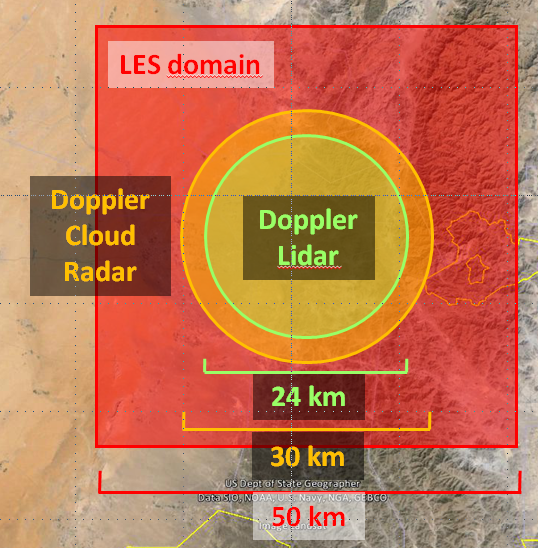
Fig.1: Design of the proposed UAE field experiment for studying the pre-convective environment. Left panel: The DL and the DCR will observe circular areas with similar diameters of »24 and 30 km, simultaneously. We propose to combine these measurements with the mobile NCMS radar and the UAE radar network. The LES domain is also shown. Right panel: Volumes covered by the DL (green) and DCR (orange).
b) Development and application of a model system chain down to the LES scale
A key aspect of our research program is the application and improvement of WRF-NOAHMP for optimized nowcasting and short-range forecasting of convergence zones and CI. Key components of the model are presented in Fig.2. The model will include advanced physics of LSA exchange, ABL turbulence, aerosol-radiation interaction, and cloud microphysics specifically tested for the UAE region. We will also consider what microphysical scheme can best be combined with cloud seeding schemes. However, the goal of our project is not the simulation of cloud seeding yet. In this phase, major weaknesses of present model systems, the simulations of convergence zones and CI, will be eliminated. We consider this as pre-requisite for accurate simulations of clouds and precipitation.
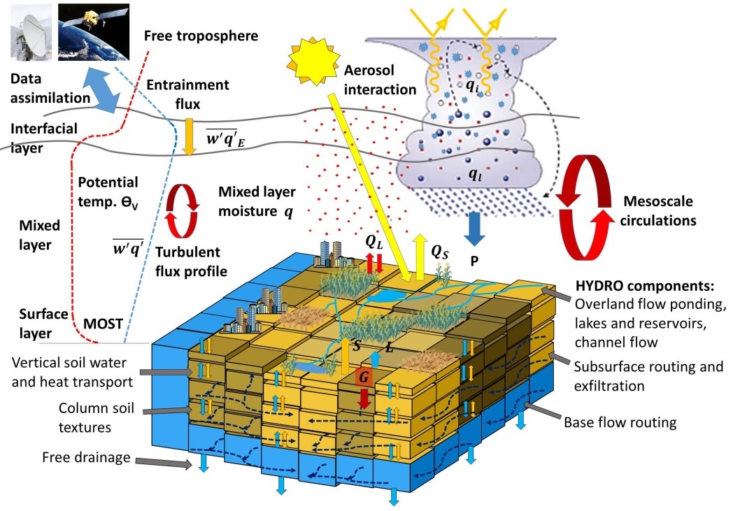
Fig.2: Key processes implemented in the IPM version of the WRF-NOAHMP-HYDRO model system. The HYDRO component will be added in a future phase allowing for a consistent simulation of fluxes through land system compartments
This work builds on the long-term expertise and excellent infrastructure of IPM with respect to regional climate and weather simulations. The proposed chain of model domains and resolutions is depicted in Fig.3.
WRF-NOAHMP will be set up for a domain covering the UAE with a resolution of »3 km forced at the boundaries by the global deterministic analyses and the variational EPS of ECMWF. This will lead to advanced model performance in the inner domains, as these are dependent on accurate representations of the large-scale meteorological conditions over and upstream of the UAE. In combination with an ensemble selection technique and the perturbation of model physics (turbulence and microphysics) an ensemble of simulations will be realized and tested. The model chain will be operated for several critical cases chosen in collaboration with NCMS. A similar chain will be operated in RCII introduced below. The infrastructure and experience is already available at IPM.

Fig.3: Proposed model domains and resolutions. In the outer domain, the DA system is operated. The experimental sites and some hypothetical plantations are also shown.
Nowcasting to short-range forecasting of convection will be improved by means of DA. The setup of the IPM forecast system is presented in Fig.4 and represents the state-of-the-art of convective scale DA. Since recently, also satellite radiances can be assimilated. Due to lack of observations, DA of clear-air dynamics and thermodynamics is still poor though the expected impact should be very strong. This is an important gap to be closed using the DL data with our project.

Fig.4: Design of the IPM DA system with an overview of the currently used (black) and the envisioned (blue) data sets. ZTD: zenith total delay, STD: slant total delay, AMV: atmospheric motion vector.
For radar DA, a new operator will be applied developed at IPM. The Doppler and reflectivity data of the UAE radar network, in combination with all other available in-situ, radio sounding, and remote sensing observations will be assimilated using a 3DVAR in combination with a rapid update cycle (5-15 min). For each ensemble member, the 3DVAR cycle will be applied extending our simulations to an ensemble-based 3DVAR (En3DVAR). We will also test whether the new WRF 4DVAR will improve the model analyses. Thus, we aim to forecast the location and timing of convergence zones and CI with unprecedented accuracy and lead time including estimates of the forecast uncertainty. We consider this set up essential for improving process understanding, model sensitivities, and cloud seeding guidance.