OCAL - Optimizing Cloud Seeding by Advanced Remote Sensing and Land Cover Modification
A project funded by the UAE Research Program for Rain Enhancement Science (UAEREP)
A prerequisite for significant precipitation amounts is the presence of convergence zones at the land surface. These are due to land surface heterogeneity, orography as well as mesoscale and synoptic scale circulations. Only, if these convergence zones are strong enough and interact with an upper level instability, deep convection can be initiated. For optimal cloud seeding deployment, it is essential that these convergence zones are detected before clouds are developing in order to preempt the decisive microphysical processes for liquid water and ice formation.
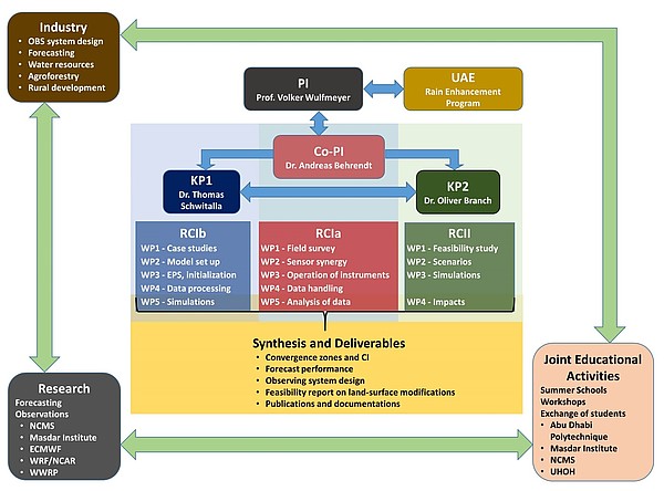
This project has two components. The first component focuses on an improved detection and forecasting of convergence zones and convection initiation using a combination of two new methodologies. The first methodology is the set up and operation of a scanning Doppler lidar and cloud radar systems for detecting convergent flows in the clear and cloudy atmospheric boundary layer. Out institute has outstanding experience in active remote sensing technologies because it operates worldwide unique scanning, high-resolution aerosol, water-vapor, and temperature remote sensing systems. We will apply the lidar-radar sensor synergy during two field campaigns for studying convection initiation in orographic terrain and over the desert in the United Arab Emirates (UAE).
The second methodology is the forecasting of convergence zones and convection initiation by a new generation of high-resolution models with advanced physics of land-surface-atmosphere exchange and radiation-aerosol-cloud interaction. We apply the WRF-NOAHMP model system, which includes improved simulations of these processes as well as new representations of dynamic vegetation and irrigation optimized for arid regions. Nowcasting to short-range forecasting of convection will be improved by the assimilation of Doppler lidar and the UAE radar network data. For the latter a new model forward operator will be applied developed at our institute.
The data assimilation system is based on a 3-dimensional variational analysis with a 5-15 min rapid update cycle designed at our institute as well. This will lead to a prediction of the location of convergence zones and the timing of convection initiation with unprecedented accuracy and lead time for cloud seeding. Forecast uncertainties will be assessed by ensemble simulations driven by ECMWF boundaries.
The second component of our project will study whether artificial modulations of land surface heterogeneity are possible by plantations or changes of terrain leading to an amplification of convergence zones. This is based on our pioneering work on high-resolution modeling of the impact of plantations on weather and climate in arid regions by local changes of land surface feedback. We demonstrated that a specific design of the shape and location of plantations can lead to the formation of convergence zones, which can support convergent flow already existing in the region of interest, thus amplifying convection and precipitation. We expect that this method can be successfully applied in regions with already existing land-surface heterogeneity and orography such as along the coastal areas with land-sea breezes and in the Al Hajar Mountain range.
Therefore, this project will supply the UAE with unique methodologies and forecasting capabilities for cloud seeding research and guidance.


